What is the Wild Atlantic Way?
The Wild Atlantic Way (or WAW) is a 2,600km – 2,700 km route along the rugged West Coast of Ireland that takes you through up to 9 of the 32 counties on the island of Ireland.
You can easily make it through 10 counties if you encroach into Derry in Northern Ireland at the start or end of your trip.
The actual distance depends on the routes you decide to travel. On this site, I also have created a few extra routes close to the WAW which are worth visiting if you have time. They add about another 250+km to the distance.
The Wild Atlantic Way works its way from Head of Kinsale in co. Cork all the way North along the West Coast of Ireland to the Inishowen peninsular in co. Donegal. Or you can of course travel South, depending on your preference.
The Wild Atlantic Way has been developed by Fáilte Ireland to encourage tourism to the West coast of Ireland, which is full of wonderful scenery and things to do and see.
The Wild Atlantic Way Map
The Wild Atlantic Way works its way from Kinsale in co. Cork all the way North along the West Coast of Ireland to the Inishowen peninsular in co. Donegal in the North. It starts in Kinsale and ends in Muff.
This site contains individual Wild Atlantic Way Google Map Routes that cover this entire trip. They can be found on the individual blog posts describing the route or on the Routes page.
You can of course travel the Wild Atlantic Way in both directions.
Signature Points and Discovery Points along the Wild Atlantic Way
The Wild Atlantic Way route passes 15 ‘Signature points’ (so-called Iconic must-see Wild Atlantic Way destinations) along the way which are as follows:
- Old Head of Kinsale, Cork
- Mizen Head, Cork
- Dursey Island, Cork
- Skellig’s View, Bray Head, Kerry
- Blasket’s View, Kerry
- Loop Head, Clare
- Cliffs of Moher, Clare
- Derrigimlagh Bog, Galway
- Killary Harbour, Mayo
- Keem Strand, Mayo
- Downpatrick Head, Mayo
- Mullaghmore Head, Sligo
- Slieve League, Donegal
- Fanad Head, Donegal
- Malin Head, Donegal
Click on the links above to bring you to the relevant route blog post.
Some of these points are more impressive than others, and what you will want to visit depends on your preferences.
Signature points are marked with a red coloured icon on the route maps. You can find the icon colour legend in the link. This will help you navigate to the sites you wish to visit and plan your trip.
Wild Atlantic Way Signs
Along the road you will see signposts like this one to indicate the direction of the Wild Atlantic Way using the blue WAW logo shown below:

You have to love some of the Irish place names!
The Wild Atlantic Way signs locations normally give advance notice of a place coming up, but sometimes they are easy to miss.
The official Wild Atlantic Way route also has a few hundred ‘Discovery’ Points along the way. These are often indicated with a sign like this one, showing the official WAW logo:

Wild Atlantic Way Discovery Points are marked with an orange coloured icon on the route maps. You can find the icon colour legend in the link.
These ‘Discovery points’ and ‘Signature Points’ are normally marked at the spot with a rusty metal sign with the official Wild Atlantic Way wavy logo on the top, like this one:

Normally Discovery points are accompanied by an information board giving useful info about the local points of interest, looking like this:

These information boards are generally very informative and give you some details on the place’s local history. They are also normally well legible.
Finding the Wild Atlantic Way Signs
You may be surprised to find some places marked that are not on the WAW documentation, and others may be difficult to find. But that just adds to the fun, making it like a treasure hunt.
This site will give you original information and photographs of all the 200 or so mainland Discovery Points along the route, having been there myself or having had them recommended to me.
Note that some of the Discovery Points and Signature Points are actually Islands so you may have to take a ferry or a cable car (only for Dursey Island) to get there!

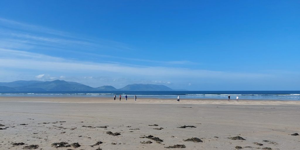
Some of the pictures may show grey skies and others blue, but that just indicates the weather variations you may encounter during your trip. After all, Ireland is known for having 4 seasons in a day!!
I hope the information you will find on this site will enhance your visit and enable you to have the greatest time during your trip.
How long does it take to drive the Wild Atlantic Way?
The Wild Atlantic Way Ireland Map
This is entirely up to you. Many things can affect this variable. Your method of travel, your budget, what you wish to see along the way, the weather, and your travel companions can all affect the length of your trip.
Looking at the total distance there is about 50-60 hours of actual driving time. But do not think you can do this in a few days!
With photo stops, filling-up stops, lunch stops, sleep and convenience breaks along the way you will need to at least triple that. Over a period of 2 years, it has taken me several weeks, with short stops along the way.

And believe me, unless you are really confident, you may not want to drive all of these roads at night. Especially if you wish to visit museums or other sites of interest during your trip. And of course, you have to stop at some pubs along the way and sample the delicious seafood chowder or an authentic Irish stew.
You will find the roads are a real mixture of quality two-lane tarmac roads to single-track narrow roads, some of which may even be gravel or maybe even with some grass growing in the middle. But do not expect to find many 4-lane motorways or highways along the WAW. It is not that kind of road trip. But you may need to drive some highway to get to the Wild Atlantic Way.

Driving in Ireland
If you are at all worried about driving in Ireland, try reading this article about driving in Ireland. And remember to drive on the left!
The WAW is such a beautiful road trip, you will want to take your time to enjoy it fully.
Your journey will basically take as much time as you can spare, and one thing is for sure, that is that you will want to come back for more.

Of course, not everyone has the time to do this journey in one go. You can always just do the trip in stages, as I did, depending on your interests and the amount of time you have available.
In one week you can still do a reasonable stretch of the WAW and see a lot.
I myself have travelled the WAW in several stages to be able to create the content for this website. To give you an idea, it took me 3 full days to visit all the sites in Donegal on the bike, without having any time to stop and visit museums etc. I will do that on later visits.
And it was all worth it just to get a shot of the End of the Wild Atlantic Way sign in Muff:

So decide what you want to see when you plan your trip. Use my website and my routes to help you.
But how to best travel the Wild Atlantic Way?
There are many ways to travel the WAW; by car, by camper, by motorcycle, like myself, by bicycle, or if you are really ambitious and have plenty of time, you could even try public transport.
But personally, I think the best way is by car or motorcycle. When you travel by car you are in charge of your own destiny and can go pretty much where you wish.
In a camper, you are likely to find that some of the roads and car parks are inaccessible and height limited to 2m which may restrict where you can go and park.
On a motorcycle, you are more limited in the amount of camping gear you can carry and more exposed to the Irish weather, but you are more aware of your surroundings. And on the right bike, you can go off the beaten path and explore even more.

And of course, if you are really nuts you can always cycle the Wild Atlantic Way. We once had a guest stay at our B&B who was doing that on a uni-cycle! This would not be my recommendation if you want to enjoy the journey, but each to his/her own.
If you wish to read more, then read my post ‘How to travel the Wild Atlantic Way’.
Either way, you will have a wonderful adventure.
And remember if at the end of your trip you head to Derry, you may wish to follow the Causeway Coastal Route in the UK, which will take you through to Belfast.

Now read ‘How to use this site’ to get the most out of your trip.
Where to stay on the Wild Atlantic Way
I have mostly stayed in campsites along the WAW. The ones I have stayed at are shown on the maps. I have also stayed in a few BnB’s along the way. We would recommend Booking.com for finding and booking your accommodation.
Make sure you plan your trip accordingly and book on time, as accommodation can get booked up over the summer period. Even the campsites can be full over the summer so book as soon as you can. Often you can cancel without penalty if you have to change your plans (depending on the booking).
Here are some other useful links for planning your trip below:
TRAVELING TO IRELAND SOON?
Here are my recommended travel resources for planning your trip:
- Book your flights: Expedia & Kayak
- Hotels & Accommodation: Booking.com, Hotels & VRBO
- Tours & Activities: GetYourGuide
- Car Rentals: Booking.com, Expedia or Discovercars
- Interactive Wild Atlantic Way Guide Maps
- Travel Essentials: Ireland Packing List
This Routes link shows you all the routes on this site.
HAVE A GREAT TRIP!!!
Last Updated on December 29, 2025 by Gav