County Sligo – WAW Routes
County Sligo is one of the counties that the Wild Altantic Way passes through, and it contains a few Discovery Points and one Wild Atlantic Way Signature point at Mullaghmore Head.
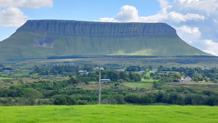
The route has good roads which are easy to drive and passes some lovely beaches. The Sligo scenery varies but is pretty spectacular once you get close to Benbulbin, which can be seen for miles around and rather commands the Sligo scenery.
Mullaghmore Head itself, is perhaps not as amazing as some of the other Discovery Points along the Wild Atlantic Way. Having said that, the views back to Belbulbin encompassing Classibawn castle from that area can be fairly awesome.

The Wild Atlantic Way Route through County Sligo
I have created one route through county Sligo (which actually starts in Mayo and ends over the border in Donegal), just for ease of use.
Like all my routes the driving time is indicative as you will want to stop along the way and visit places.
An alternative along this route is also a potential detour to the Glencar Waterfall which is actually in county Leitrim. This would add another 30 + minutes to your journey, plus the stop time.
The grave of W.B. Yeats is also along this route.
This route also takes you to the impressive Gleniff Horseshoe in the Sligo Mountains which is well worth the extra detour.

And if, of course, you stop to do a hike around or up Benbulbin it will seriously increase your journey time. If hiking or walking is your thing you could easily spend a few days enjoying Sligo.
The route also passes through the county town of Sligo. We only passed through Sligo on the route, but it is quite a large town with an important history as a port. It is the biggest town in the county and it does take a while to pass through due to the traffic lights in the town.
But if towns are your thing, then maybe this would be a good place for you to stop?
So make sure you plan your route effectively while you are here, and see the things you want to visit.
Wild Atlantic Way Route Google Map Sligo
Route 1. Ballina to Tullan Strand [Blog Post – read this for more detailed info on the route]
Approx. 173km distance, 3 hrs 27 minutes driving time
When we travelled through Sligo we stayed at Strandhill Campsite which was actually a great place to stop, with the Strand Bar in walking distance from our tents.
Read the relevant blog post for more detailed information on this route.
TRAVELING TO IRELAND SOON?
Here are my recommended travel resources for planning your trip:
- Book your flights: Expedia & Kayak
- Hotels & Accommodation: Booking.com, Hotels & VRBO
- Tours & Activities: GetYourGuide
- Car Rentals: Booking.com, Expedia or Discovercars
- Interactive Wild Atlantic Way Guide Maps
- Travel Essentials: Ireland Packing List
Next County – South
Next County – North
Last Updated on December 29, 2025 by Gav