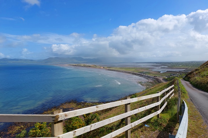
The Wild Atlantic Way in gorgeous County Kerry
County Kerry has some of the prettiest beaches and views along the Wild Atlantic Way.
County Kerry is located along the South Western part of Ireland and forms part of the Province of Munster.
There are two Wild Atlantic Way Signature Points in County Kerry:
Kerry has some fantastic roads to explore and can be quite touristy during the summer months as there are so many wonderful places to visit.
There are beautiful sandy beaches hidden away along the south side of the Shannon estuary, as well as some wonderful golf courses like Ballybunion or Tralee.
Inch Beach, Conor Pass or Slea Head Drive on the Dingle Peninsular are all spectacular places to explore. Several famous movies have been filmed in Kerry over the years (Ryan’s Daughter, Star Wars, Far and Away etc).

Rossbeigh Strand, Killarney National Park, Derrynane and some of the ‘gaps’ crossing the Iveragh Peninsular are all wonderful. It is very difficult to make the choice of what to visit. So why not visit it all?!
Even a visit to the Skellig Islands (from Star Wars fame) or the Blaskets are things to do while in County Kerry.

My routes in county Kerry tend to head North to South, as that is the direction I travelled them, but of course, you can follow them in either direction.
The exception is when driving the Ring of Kerry, as all the tour buses have to drive in an anti-clockwise direction. So it is better to travel it in a clockwise direction to avoid getting held up by the buses. It also means it is easier to stop at the viewpoints which tend to be located on the left-hand side of the road.
For County Kerry I have documented four routes. Three along the Wild Atlantic Way and one across the mountains, covering 2 gaps, or passes, on the Iveragh Peninsular.
Click on the link to the relevant blog posts for more detailed information on that route.
Wild Atlantic Way Routes County Kerry
Route 1. Killimer-Tarbert-Tralee (along the WAW) 97km / 2hrs, 41 minutes driving time
Link to: Killimer-Tarbert-Tralee [Blog Post]
Link to: Killimer-Tarbert-Tralee (Route link with POI’s and descriptions)
Route Summary for Killimer to Tarbert to Tralee route
This route starts at the ferry port in Killimer, Clare.
But either Killimer or Tarbert could be a starting or end point depending on which way you are travelling.
If you arrive at Shannon airport for example, Killimer is a bit closer to the airport, but if you were travelling south and missing out on county Clare (but why on earth would you do that!! ) you would drive straight to Tarbert and take in the Shannon Estuary Route on the way.

This route follows the coast and some lovely wide and sandy beaches (Wild Atlantic Way Discovery Points) along the mouth of the estuary, through Fenit and into Tralee, the county town of Kerry, which is at the entry to the Dingle peninsular.
Route 2. Tralee to Killarney via the Dingle Peninsula. 201km / 4 hrs 3 minutes driving time
Link to: Tralee to Killarney via Dingle Peninsular [Blog Post]
Link to: Tralee to Killarney via Dingle Peninsular (Route link with POI’s and descriptions)
Route Summary for Tralee to Killarney Route
This route takes you around the Dingle Peninsular, including Slea Head Drive and Conor Pass (the drive to Killarney is not strictly the Wild Atlantic Way, but it enables you to drive the Ring of Kerry next and is worth the detour).
There is a lot to see along the way. I have mostly travelled this trip in a clockwise direction, but this is not necessary, although I would recommend travelling the Slea Head drive part clockwise. Just because the stopping points tend to be on the left-hand side which makes it a bit safer.

If you are lucky you may see whales or dolphins here off the Blaskets. This route is quite a long journey of about 200km and will take you a good day if you want to stop and see the sights along the way. But I think it is worth taking your time along here.
Route 3. The Ring of Kerry along the WAW (from Killarney) 199km / 4 hrs 12 minutes driving time
Route Summary for Ring of Kerry route.
This route mostly follows the Ring of Kerry, on the Iveragh Peninsular, but travels along the WAW where possible, including Valentia Island. In season it is best driven in a clockwise direction to avoid getting caught behind tour buses (and be closer to the sea, making photo stops easier).
There are some interesting places to stop along the way so to make the most of it, this trip is likely to take you a full day, with a stop for lunch etc.
Link to: The Ring of Kerry along the WAW [Blog Post]
Link to: The Ring of Kerry along the WAW (Route link with POI’s and descriptions)
Route 4. Gap of Dunloe and Ballaghbeama Gap (NOT WAW), Iveragh Peninsular 101km / 2 hrs 22 minutes driving time
Route Summary for Gap of Dunloe and Ballaghbeama Gap route.
If you are a keen explorer, this route is a fun driving route. The route is not on the WAW but if you are already on the Iveragh Peninsular, then it is a shame not to see these passes.
There are wonderful views of the highest mountain in Ireland, Carrauntoohil. But beware: many of the roads are single-track with bends and limited passing points. You need to be a competent driver and able to reverse if need be.

During busy periods, you may well get held up, and the occasional accident does happen here.
The time estimate is based on an empty road. So be aware – it will take you longer than I have calculated – there is no racing along this route!
You can watch videos of my driving The Gap of Dunloe and the Ballaghbeama Gap in the links.
Link to: Gap of Dunloe and Ballaghbeama Gap [Blog Post]
Link to: Gap of Dunloe and Ballaghbeama Gap (Route link with POI’s and descriptions)
I hope you have enjoyed this journey into County Kerry. My next route going South will be from Kenmare into County Cork, along the beautiful Beara Peninsula, travelling South.
TRAVELING TO IRELAND SOON?
Here are my recommended travel resources for planning your trip:
- Book your flights: Expedia & Kayak
- Hotels & Accommodation: Booking.com, Hotels & VRBO
- Tours & Activities: GetYourGuide
- Car Rentals: Booking.com, Expedia or Discovercars
- Interactive Wild Atlantic Way Guide Maps
- Travel Essentials: Ireland Packing List
Last Updated on December 29, 2025 by Gav