Glengarriff to Baltimore Driving Route
This Wild Atlantic Way route from Glengarriff to Baltimore takes you along the coast of two peninsulas: Sheep’s Head Peninsula and Mizen Head Peninsula.
The route passes through the town of Bantry and takes you to the most southerly point of the Wild Atlantic Way, the Signature Point of Mizen Head.
Firstly, start by visiting Garinish Island and the Blue Pool or walk the Sheep’s Head walking trail. Or visit some islands off this coast in the Carbery’s Hundred Isles, like Sherkin Island or Cape Clear Island.
Hike to see the iconic Dunlough Castle or take a boat trip out to the Fastnet Rock Lighthouse.
There is plenty to see and visit along this route, so plan your trip wisely.
Wild Atlantic Way Map West Cork
Approx. 170 kms distance, 3 hrs 17 minutes driving time
Glengarriff Harbour
This is another Discovery Point location where you can catch a ferry to Garinish Island. The protected harbour has a large car park and you can catch the ferry from the pier.

Or charter a fishing boat and look for whales and dolphins, or see the seals on Seal Island. Or even organise a customized boat tour.

Garinish Island
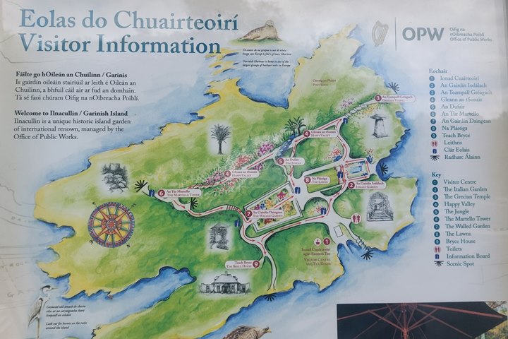
Garinish Island (or Garnish Island, also known as Ilnacullin, or Illaunacullin) is in the sheltered harbour of Glengarriff in Bantry Bay. The island used to be home to the Bryce family (Scottish MP/ambassador) but was donated to the Irish state in 1953 following the death of Roland Bryce.

The Island is known for Bryce house and the gardens. The Office of Public Works (OPW) now looks after them. The gardens of Garinish were developed by the partnership of Annan and Violet Bryce and gardeners Harold Peto and later Murdo Mackenzie. The house is kept in its original state and you can visit in person or online on the website.
The gardens include a Grecian temple, a clock tower, a casita (or Italian summer house), and an original Martello Tower.

You can visit the island (between March and September) by catching a ferry from Blue Pool Pier or Glengarriff. The boat trip takes 10-15 minutes and you may be lucky to see the seals on the journey.
Blue Pool Pier

You can get the ferry from here to Garnish Island from the picturesque Blue Pool. The Blue Pool is a lovely tidal harbour 2 minutes walk from the lovely village of Glengariff.

There are signposts showing the way to the blue pool and the path is next to Quills Woollen Market in the centre of the village.
At Quills in the summer, there are food stalls laid out and it is a nice place to stop for lunch or a picnic.

The blue pool is the point where the river meets the bay and is a beautiful protected harbour surrounded by trees.
There are some signposted walks through the woods with nice views of the harbour.

The Priest’s Leap

If you are being adventurous on a motorbike or small car, this amazing gravel route takes you to the border of Cork and Kerry. It is the highest pass in Munster at 463m. It is a narrow track with very few passing places. DO NOT try this with a caravan or a camper.
It is a detour from the WAW but offers spectacular views going up and at the top.
The place name comes from an old Irish legend.
I rode it going North and encountered a herd of cows roaming loosely on the way up.
It is not recommended for large vehicles – I was initially behind a German caravan that was persuaded to turn around by a local as you would not be able to manoeuvre on this path if you meet oncoming traffic.
If you are travelling with a caravan and hence unable to drive it you can see my video here:
Gougane Barra

Gougane Barra is another short detour from the Wild Atlantic Way but well worth the visit. The valley is very scenic and is a heritage site.
There is an oratory built on a small outcrop in the middle of a lake, overlooked by impressive mountains.

For myself, it has memories of my late father who visited here on holiday with my Mum many years ago to fish in the surrounding lake and rivers.
He had many related stories including having a poacher as a Gilly, catching a cow with the fly rod, and partaking of the local potine with some detrimental consequences etc. But I will not not go into the hilarious detail of these stories here.

Bantry Harbour
Bantry Harbour looks out to Whiddy Island and across to the Beara peninsula. This is a working fishing harbour that also provides a year-round ferry service to Whiddy Island.


The harbour has a camping spot for campers.

Whiddy Island
Whiddy Island is opposite the town of Bantry and has a much-reduced population compared to previous years. There are oil storage facilities on the Island related to the famous Whiddy island disaster in 1979, when an oil tanker, Betelgeuse, exploded at the oil terminal, claiming 50 lives.

You can visit the island during the summer and follow some of the Sheep’s Head Way walking paths.
Seefin Viewpoint

This Discovery point with Discovery point sign and information board is at the legendary Finn Mac Cool’s (Fionn mac Cumhaill) seat. This has panoramic views to Bere Island and Bantry Bay.
There are some picnic tables which are a great place to eat your packed lunch. This is the only Discovery point I have found on the Wild Atlantic Way with TWO separate Discovery Point signs.

The Seefin ridge runs along the Sheep’s Head peninsula so you have great views down to both Bantry Bay and Dunmanus Bay on both sides.
There is a religious monument nearby and signposts for the Sheep’s Head Way walking route.

Sheep’s Head
The Sheep’s Head Discovery Point is located at a car park with public toilets. There is a walking path that leads to the lighthouse at the end of the Sheep’s Head.

The walk is quite a long one though (2km) and dogs are not allowed, even on a leash.

The Sheep’s Head peninsula is home to the Sheep’s Head Way Walking Trail.
The Sheep’s Head peninsula is a popular trail for walkers between Bantry Bay and Dunmanus Bay in County Cork.

On a clear day there are great views across Bantry Bay to the Beara Peninsula. There is a coffee shop here where you can get a cup of tea and a bowl of soup.

Sheep’s Head Lighthouse
This lighthouse on the Sheep’s Head peninsula at the head of Bantry Bay is 7 meters high. It is built into the rocky cliffs of Sheep’s Head. The lighthouse is about a 30-minute walk from the Sheep’s Head discovery point sign on a rocky pathway.

The lighthouse began operations in 1968. It started automatic operation in 1993. The original EIRE 31 sign from WWII is nearby.
Dooneen Pier
Dooneen Pier is close to Kilcrohane in West Cork. It has a pier ideal for fishing and diving as it is a sheltered spot.

You can climb down steps to get to the sea. it is accessible via a single-tracked lane and there is no real parking space or turning point available, except on the pier itself. Not suitable for a camper van for example.

Altar Wedge Tomb

This stone-age wedge tomb looks across Toormore Bay towards Mizen head. There are some lovely views from here.

The tomb is easily accessible from the car park, being just a short walk away. The car park is not that large and holds only about 10 cars. It is easy to miss the signpost as you drive past (as you come up on the entrance quite quickly).

The tomb dates back to around 2000-2500 BC. It is thought that Bronze Age families may have honoured their ancestors here.
More recently Catholic Priests would hold services here when it was illegal to hold mass in church.
Barley Cove
This beautiful cove is a sandy beach near Mizen Head.

This beach was designated as a Special Area of Conservation under the European Habitats Directive.

A floating pontoon provides access to the beach over the dunes on the far side of the beach. The dunes were created by a tsunami caused by an earthquake in Lisbon, Portugal in 1755, that deposited the sand at the back of the beach.

The beach has lifeguards during weekends in the summer months.
The Barley Cove Beach Hotel has great views over the Barley Cove beach. You can eat lunch or dinner here and there is a cafe outside where non-residents can get an ice cream or waffle and a cup of coffee.

Dunlough Castle
This iconic fort or castle is a short detour off the Wild Atlantic Way.

This Fort of Castle, Dunlough Castle, is at a most impressive location overlooking some awesome cliffs. It closes off the Three Castle Head at the tip of the Mizen Head Peninsula.

It can be reached with about a 30-minute hike over somewhat unclear paths. On one side you have freshwater Dun Lough and on the other some fearsome 100m tall cliffs.
There is a car park with a small parking fee. The road to the car park is quite tight and narrow.

There is a legend that a ‘White Lady ‘ roams the lake and if you are unfortunate to spot her, you will die very soon!

The present remains date back to the 15th century., but the original building dates back to 1207.
Mizen Head

The Head at Mizen Head is the most Southerly point on the Wild Atlantic Way. It is also the most South Westerly point on the Island of Ireland. There is a fee to enter the site.
The old Keeper’s House now has a cafe and shop inside. Check the website for opening times, which can vary.

When I visited here some new construction was still being done at Mizen Head. The upper site has a large car park and visitors centre and the cafe. The visitor’s centre has some interesting things to see.
For example, there is a photo montage about the building of the amazing Fastnet lighthouse, which can be seen on a clear day from the site.

There is also a mock-up showing how this amazing lighthouse was built with interlocking granite blocks back in the years leading up to 1904.

The lower site, which is accessed via a pedestrian bridge, has the Signal Station and viewpoint.

Mizen Head was built as a signal station in 1910. Later it became the home of Ireland’s very first radio beacon in 1931. The visitor’s centre has a navigation aids simulator and also tells the story of Marconi in Crookhaven.

There is some stunning scenery to be seen on the walk down to the Signal Station, with a chance of spotting whales and interesting birdlife. The walks can be quite strenuous as they have steep inclines.
Colla Pier
Colla Pier is a small fishing pier which has a ferry to Long Island. The ferry journey takes about 5 minutes.


Long Island
Long Island (in Irish Inish Fada), is a sparsely inhabited island located south of Schull. The island is approx 5km long yet quite thin, hence its name.

Like many of the islands on the coast of West Ireland, Long Island offers peace and quiet from the normal hustle and bustle of life.
Some of the houses have been restored on the Island and you can enjoy the wild flora and fauna and pleasant walks. Do some bird watching or just enjoy the tranquillity. There is no pub on the island.

There is a paved road on the island, and another somewhat overgrown road leads to an old copper mine and the Copper Point lighthouse in the East.
The lighthouse protects the entrance to Schull Harbour.
You can have a castaway stay here if you are looking for some solitude.
The Island looks out to the famous Fastnet Rock, south of the Island, famous for the Fastnet race, famous for the 1979 Fastnet Race disaster.
Copper Point Lighthouse
This white tower, originally a beacon, located on Long Island, is now classified as a lighthouse. There is a precarious walk over the rocks to reach the tower.

Schull Harbour
Schull is a charming little tourist village on a natural inlet. The harbour is a fishing harbour also used for sailing and diving.

There is a fish and chip shop down on the harbour itself. The Schull Harbour Hotel overlooks the inlet and is a good place to stay (with a small indoor swimming pool, gym, sauna and steam room and a great breakfast).

There is public parking opposite the hotel and a short walk brings you to the harbour. Schull is opposite the famous Fastnet rock.

Take a boat trip out to the rock or Cape Clear Island.
Cape Clear Island
Cape Clear, or Oileán Chléire, is a Gaeltacht island 13km off the coast. It is Ireland’s most southerly inhabited island and can be reached by ferry.
Saint Ciarán, is the island’s patron saint, and the islanders celebrate his feat day on 5th March every year.
The island’s location makes it attractive for marine life, and you may be lucky to see whales, dolphins or basking sharks off the coast.
The island has some of its old heritage still visible with remains of standing stones churches and castles still visible.
Cape Clear has a gin distillery on the island and there are cottages to rent for a quiet retreat from the world. There is a bus available for bus tours on the island.
There is great walking on the island with plenty of flora and fauna to see.
Fastnet Rock Lighthouse

This amazing building was built from Cornish granite by William Douglass, and finished in 1904, having taken 5 years to build.
This lighthouse is famous for the Fastnet Disaster in 1979 when 19 people lost their lives during a storm. The Fastnet race is a biannual event that sails from Cowes to Fastnet and back to Plymouth via the Scilly Isles.
Of the 303 starters only 86 finished the race. 194 yachts retired and 24 were abandoned in Force 10/11 winds. I can remember seeing parts of some yachts being washed up on the beach in Cornwall after the race that year.
The lighthouse has been unmanned since 1989.
It is possible to visit the rock by boat from Cape Clear Island when the weather permits.
At Mizen Head there is a lot to see about the history of the Lighthouse. They have an exhibit showing how the building was made with interlocking granite blocks to defend against the worst weather the Atlantic can throw at it. It is still standing one hundred and twenty years later.

Cunnamore Pier

Cunnamore Pier is accessible via a narrow road. From Cunnamore Pier you can catch a ferry to Heir or Sherkin Islands. The Heir ferry takes only 4 minutes.
The pier is a great spot for a swim. There is parking available at the pier.

Heir Island
Heir Island (also known as Hare Island or Inis Uí Drisceoil) is located in Roaringwater Bay. There are a few other islands nearby with Sherkin Island, Cape Clear, the Calf Islands, the East and West Skeams.

There are a few places to stay and eat on the island. It is one of the Carbery’s Hundred Isles. Like many West Coast islands, you can see plenty of rare flora and fauna on the island. It is a great getaway if you are looking for some peace and quiet.
There is a sailing school on the island which you can also explore on a bicycle.
Inishbeg

Inish Beg is actually an island and about a third of the island is the Inish Beg Estate.
The Estate is a good location for self-catering holidays and has some beautiful woodlands, parkland, farmland, and gardens. There are some luxury self-catering cottages, some of which are on the waterfront, with access to an indoor heated swimming pool and steam room.

The gardens at Inish Beg Estate are open to the public all year round and there is a small entry fee to get in. You can explore the trails and
The Island also provides other activities such as horse-drawn carriage rides, cookery courses, sea kayaking, yachting, scuba diving, whale and bird watching.
Sherkin Island

This island (or Inis Arcain in Irish) is located across from the fishing village of Baltimore. This island is one of Carbery’s Hundred Isles. The island is 10 minutes from Baltimore by ferry.
The ancestral castle (Dún na Long) of the O’Driscoll clan overlooks the entrance to Baltimore harbour. The island was attacked in 1537 as reprisals for the O’Driscolls stealing 72 tuns of what must have been very tasty wine from The Santa Maria de Soci, a Portuguese ship that had been moored in Baltimore harbour.
There are also the ruins of a 15th century Franciscan Friary, known as ‘the Abbey’ (Mainistir Inis Arcáin) on the island close to the castle.

Sherkin has an automated lighthouse on the island, dating back to 1835. This is located opposite the Baltimore Beacon.

There are a few places to stay on the island where you can have a relaxed holiday break.
Sherkin has a few sandy beaches which are especially great swimming areas.
Baltimore Harbour
The harbour town of Baltimore is a bustling tourist town which gets quite busy during the summer months.

The town has several Festivals and events each year which consequently bring in the tourists. Deep sea angling festivals and Regattas are all part of life in Baltimore.

Baltimore also has a large harbour. Baltimore Harbour is one of the ferry ports where you can get to a number of the nearby islands including Heir, Sherkin and Cape Clear Islands.

The harbour is also an embarkation point for divers as there are a few shipwrecks off this coast including a WWII German submarine, the U260, at 40-45m depth.
There is also a large car park next to the harbour.


If you fancy a walk, why not stroll up to the Baltimore Beacon, a cone-shaped Beacon opposite Sherkin Island? It is but a 2km walk from the town and there are super views over to Sherkin Island and into Baltimore Bay.

I hope this route helps you to plan your trip so that you can enjoy the beautiful Cork scenery along the way!
TRAVELING TO IRELAND SOON?
Here are my recommended travel resources for planning your trip:
- Book your flights: Expedia & Kayak
- Hotels & Accommodation: Booking.com, Hotels & VRBO
- Tours & Activities: GetYourGuide
- Car Rentals: Booking.com, Expedia or Discovercars
- Interactive Wild Atlantic Way Guide Maps
- Travel Essentials: Ireland Packing List
Next Route – Going North
Next Route – Going South
I have spent many (fun) hours creating this website to help people travelling the Wild Atlantic Way. If you found it useful and it helped you plan your trip, please consider donating towards my petrol/gas bill! Many thanks!
Last Updated on October 13, 2025 by Gav