Donegal : Narin/Portnoo to Rosguill along the Wild Atlantic Way
This Wild Atlantic Way driving route from Narin/Portnoo to Rosguill Peninsula takes you North along the coast of the beautiful County of Donegal.
The trip also takes you close to the imposing mountain of Errigal, which is the highest peak in Donegal at 751m near Gweedore. Take a detour and hike the mountain or go camping in Glenveagh National Park nearby.
There are some other interesting places to visit along this route. You can take ferries to Gola and Tory islands or Arranmore. Or visit the wreck of Bad Eddie or the ruins of the McSweeney family stronghold at Doe Castle.
When on the Rosguill Peninsula you can visit the Singing Pub or take a hike to the famous Murder Hole Beach which is now more easily accessible.
The route from Marin/Portnoon to Rosguill also passes Donegal Airport which has daily flights to Dublin.
There are some lovely views and roads along this part of the Wild Atlantic Way. And don’t forget some of the hidden desolate beaches that can be explored if you are adventurous enough.
The route passes some interesting harbours with fishing histories and there are some great camping spots along the way, like Sleepy Hollows and Rosguill Holiday Park.
Wild Atlantic Way Donegal Map
Approx. 147 kms distance, 3 hrs 8 minutes driving time
Download the route map to your phone with ALL the points of interest included here: Narin/Portnoo to Rosguill.
Narin/Portnoo Beach

This beach has plenty of parking available and looks out onto Inishkeel Island.
There are toilets available in the car park and there is easy disabled access to the beach. Nearby there is the Narin and Portnoo Links golf course, located in the dunes. Lifeguards are present during the summer months.
You can walk to Inishkeel at low tide, but check the Portnoo tide times before embarking. You do not want to be caught at high tide!
There is a ruined 6th-Century Monastery on the island.
For accommodation Portnoo Donegal:
Burtonport Harbour
This interesting port is the gateway to Arranmore Island by ferry. It was built by Lord Burton, Marquess of Conyngham during the 1800’s. The plan was to develop a fishing industry on nearby Rutland Island, as there were lots of herring around back then.

However the herring left and some of the buildings were buried in a sandstorm, so the plan failed. A railway track was built to the port from Letterkenny in 1903.
There is a plaque to commemorate James Napper Tandy, who led a military force to defeat the English in the 1798 rebellion. He arrived a week too late however and fled.

Inishfree and Arranmore Islands
Inishfree Upper is the largest of two Islands known as Inishfree. Inhabited in the 4th and 5th centuries by Niall of the Nine Hostages.

Arranmore (Árainn Mhór) Island can be reached on the ferry from Burtonport and you can bring your car with you. The Island has musical events each year and is a great stop-off if you have plenty of time travelling the Wild Atlantic Way.
Donegal Airport

Donegal Airport is the gateway to the Wild Atlantic Way by air. It runs twice-daily flights to Dublin for affordable prices.
Carrickfinn Beach

Next to Donegal airport, Carrickfinn Beach is a 3,5km long sandy beach, located in the Irish-speaking Rosses part of Donegal.
It is a Blue Flag beach with a smallish car park. The Dunes behind the beach protect the runway of the airport from the pounding waves of the Atlantic.
Camping Sleepy Hollows

This is my favourite Wild Atlantic Way campsite. It is a great little campsite run by Ian and Nicola with good facilities. I have stayed here a few times and it is perfect.
The hosts are very friendly and a fire is kept going for the guests in the evening.

There are two pubs within walking distance and the campsite is biker friendly. Great facilities for cooking and BBQ’ing undercover.
There is a charming spot where you can cook undercover which serves very well to get the guests together in the evening. Especially when it is raining, which it was – very hard when I was last here. So glad to have this spot and a drying room!

But beware of the midges, they can be rampant here during some times of the year. Very close to Mount Errigal.
Mount Errigal

On the way to Glenveagh National Park and the Derryveagh mountains, Mount Errigal is not directly on the Wild Atlantic Way. But it is only a short detour to visit. It is possible to climb the mountain although it is quite a strenuous hike.

Errigal is 751m high and is Donegal’s tallest mountain. Though not directly on the Wild Atlantic Way you will see glimpses of this iconic mountain as you follow the Wild Atlantic Way. It is one of the Seven Sisters. It is a good area for hiking.

Glenveagh National Park
A small detour from the Wild Atlantic Way, this park has great trails for hiking/walking through the beautiful nature. There is plenty of parking space available.

There is a visitor’s centre and a restaurant where you can get a wholesome meal. But do not expect to get breakfast here at 12.01 pm, as I did!

There is a castle to visit and some gardens.

You can get a bus to take you to the castle for a few Euros.

The visitor’s centre has an interpretive display and free audio-visual.
Bunbeg Harbour

This quaint little protected harbour (Cé an Bhuna Bhig) was built in the 1830’s as a fishing port. In the 1890’s it was a vibrant port, providing fish and shellfish to London restaurants. These days the amount of fishing from the port is less than it was.

The port is one of the main points of departure for the ferry to Tory and Gola islands.
Gola and Tory Islands
Gola island, which was unpopulated until 1996 now again has people living there for most of the year. Normally in winter though the island will just be populated by animals and wildlife. There are some holiday homes on the island.
The island can be reached by ferry from Bunbeg during the summer season.
Tory (or Toraigh) island is 14,5 km off the coast of Donegal. Its name means a place of steep rocky heights. It is a Gaeltacht area where Irish is spoken. The island has had a reducing population over the years and in 2016 only 119 people inhabited the island.
The passenger ferries go from Magherorarty Pier and Bunbeg Harbour. The island has its own ‘King’ who acts as a spokesperson for the islanders. The island has some interesting geology and connections with history such as the battle of Tory Island in 1798.
Bad Eddie

This iconic shipwreck washed up on the beach at Magheraclogher in the 1970’s and has been a well-known tourist attraction ever since.
The Bád from Bád Eddie actually means boat in Irish. It used to belong to Eddie; Eddie’s boat. She was originally a French half-deck trawler and was purchased by local Eddie Gillespie.
Her original name was Cara Na Mara.
However, the Atlantic winds and waves have now taken their toll and the boat is beginning to disintegrate so if you would still like to see her, the sooner the better. You can park fairly close and walk out to the vessel at low tide.

The tide can rise quickly so make sure to check the tides.
Some people were even driving out onto the sand with their vehicles, but I did not want to risk getting stuck. There are no clear signposts so follow the location on the route for the parking location.
Bloody Foreland

Cnoc Fola means hill of blood. Hence bloody foreland, as the land becomes the colour of rust at sunset or in the autumn when the ferns change colour.
Nearby Gweedore Power Station used to burn peat from the nearby fields to produce electricity after WWII due to coal shortages.

Magheroarty Pier

Magheroarty Pier (sometimes spelled Magheraroarty, or Mhachaire Rabhartaigh in Irish) is another Discovery point on the Wild Atlantic Way and another place to get a ferry to Tory Island.
There is plenty of parking near the pier and a large sandy beach. There is a nice cafe there where you can have a cup of tea and a pastry, which is exactly what I did! The cafe was full of young surfers visiting the local surf school when I was there.
Horn Head

Horn Head (or Corrán Binne) Discovery point looks over to some spectacular 200m cliffs that are home to birds such as the Shag, Puffin, Fulmar, Kittiwake, Guillemots and Razorbill.

The deserted beach of Tramore is close by, and can only be reached by a long walk through the dunes.
The Ross View

This stunning view looks down to Killahoey Beach, close to the town of Dunfanaghy, a former fishing port.
Play a round at Dunfanaghy Golf Club.
Marble Hill Strand

Marble Hill Strand is a fantastic sandy beach close to Dunfanaghy. Ideal for families.
Surf schools and kayakers have fun here. Rock pools and refreshments are available in the summer. Limited parking along the road.
Doe Castle
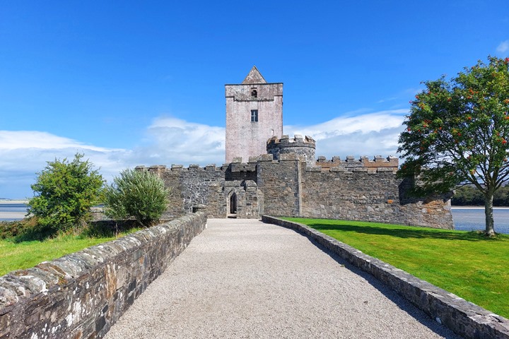
Hidden away down some small country roads, this castle is definitely worth a visit. It is not sure exactly when the castle originated.
The castle changed hands several times and ended up in the hands of the Scottish McSweeney family in the 1500’s: McSweeneys of the Territories. McSweeney Doe. (Doe comes from Tuath, meaning territory).

It was a McSweeney stronghold for more than 200 years. The O’Donnell family preceded them. The castle is well protected by surrounding land and looks out onto Sheephaven Bay.

The castle was rebuilt by General George Vaughan Hart in the late 18th century. His initials can still be seen in the brickwork of the Vaughan Hart building.

Doe Castle View

This viewpoint gives a great sighting of Doe Castle from across the bay.

Rosguill Peninsula
Rosguill or (Ros Goill) is a discovery point with spectacular views over the ocean.
There are several camping spots on this Peninsula and at the end, you can find Murder Hole Beach, which can now be reached via a path constructed by a local landowner.
Murder Hole Beach
Murder Hole Beach (Boyeeghter Strand) is renowned because of its name and its beauty.
Until recently, there was no easy access to the beach, but now there is a path leading to the beach to make it easier to get there. When I arrived there, it looked like they were charging to use the path (fair enough, I suppose, as it is private land) but it did look a bit steep for me to climb, so I have no pictures of the beach itself.

But you can Google it. The beach is divided into two parts,, which become one at low tide. The beach is known for having dangerous rip tides and currents so it is advised not to swim there. There are no lifeguards to save you if you do.
This Wild Atlantic Way route through Donegal is one that is worth taking some time on. A detour (or indeed bypass) to Errigal and Glenveagh is definitely worthwhile, depending on your preferences. Check out the icons on the map to see which route is best for you.
TRAVELING TO IRELAND SOON?
Here are my recommended travel resources for planning your trip:
- Book your flights: Expedia & Kayak
- Hotels & Accommodation: Booking.com, Hotels & VRBO
- Tours & Activities: GetYourGuide
- Car Rentals: Booking.com, Expedia or Discovercars
- Interactive Wild Atlantic Way Guide Maps
- Travel Essentials: Ireland Packing List
I have spent many (fun) hours creating this website to help people travelling the Wild Atlantic Way. If you found it useful and it helped you plan your trip, please consider donating towards my petrol/gas bill! Many thanks!
Next Route – Going South
Next Route – Going North
Last Updated on October 13, 2025 by Gav